
Oxfordshire Streets | Three Updates, One Direction of Travel
If you’ve been following transport stuff recently, you’ll know January has been a little, shall we say, ‘congested’ with news.
A new national Road Safety Strategy. New government direction on pavement parking. And here in Oxfordshire, fresh CoHSAT analysis showing that in the Cowley Low Traffic Neighbourhood, fewer cars on the streets of has meant fewer collisions
These three updates weren’t planned as a neat trilogy. But they are connected - and this blog is our attempt to join the dots and reflect what that means for daily life here in Oxfordshire; because there is a golden thread here (you just need to get to the end) .
1) The new Road Safety Strategy
The Government’s new Road Safety Strategy landed earlier in January, with a headline target to reduce deaths and serious injuries on Britain’s roads by 65% by 2035, and a 70% reduction in the number of children under 16 killed or seriously injured on road by 2035.
They’ve adopted the ‘safe system’ approach which means taking a systemic lens to change from safer roads and roadsides to safer speeds, safe vehicles, and better responses to collisions. This truly is an evidence-based ‘everything-everywhere-all-at-once-approach’ and underpinning it is a recognition that “while human error is inevitable, deaths and serious injuries are not; the road and vehicle environment should be designed to protect people as much as possible”.
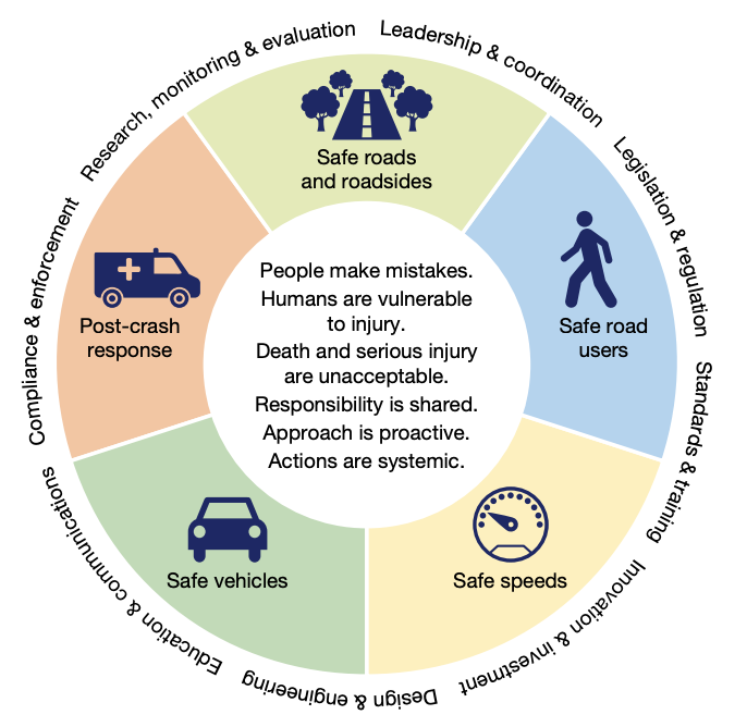
And here is an inherent tension - on the one hand it’s clear that death and serious injury are unacceptable. And yet, implicit in those targets is a level of tolerance to death and serious injury - including for children - while improvements are made.
“Everyone wants to live in a place where parents can get their children to school by walking or wheeling, where active travel feels like a safe choice, and poor driving behaviour…doesn’t go unchallenged. Well-designed and safe roads make public spaces more accessible and enjoyable for everyone”
Road Safety Strategy, p.10
In Oxfordshire, around 270 people are killed or seriously injured on our roads every year. This equates to roughly 10 coach loads of people. Once more readers - 10 coach loads.
As we said in our contribution to the CoHSAT news release;
“This Strategy gets the diagnosis right: deaths and serious injury aren’t inevitable, and safer streets unlock healthier, more liveable places. The test now is delivery – safer speeds and people-first street design, especially around schools, high streets and bus corridors. ‘Real change happens locally’. That means place-based plans with locally meaningful indicators, so communities can see what’s changing and be part of shaping it.”
The OLS watchlist (for what comes next):
We want to see place-based road safety plans for Oxfordshire that translate national ambition into local action that matters to local people
Those plans need to join up coherently with the Local Transport and Connectivity Plan and Central Oxfordshire Transport Plan, rather than living in a separate ‘safety bubbl’e.
And they need an equity lens from the start, because “safer on average” doesn’t equate to “safer for everyone”.
2) Pavements, dignity, and equity
The day after the Road Safety Strategy landed, the Government confirmed something many groups have pushed for for years: new legal powers to help councils tackle pavement parking.
But why is this such epic news you ask? Pavements carry a lot - beyond the weight bearing load of wheelers and walkers, how the space is used and allocated is indicative of a place's 'world view'. As populations have grown, ubiquitous car ownership normalised, we’ve hit the limits of street space, and cars end up creeping onto pavements. If you’re driving round tired, late, and desperate for a space, that can feel like a harmless compromise.
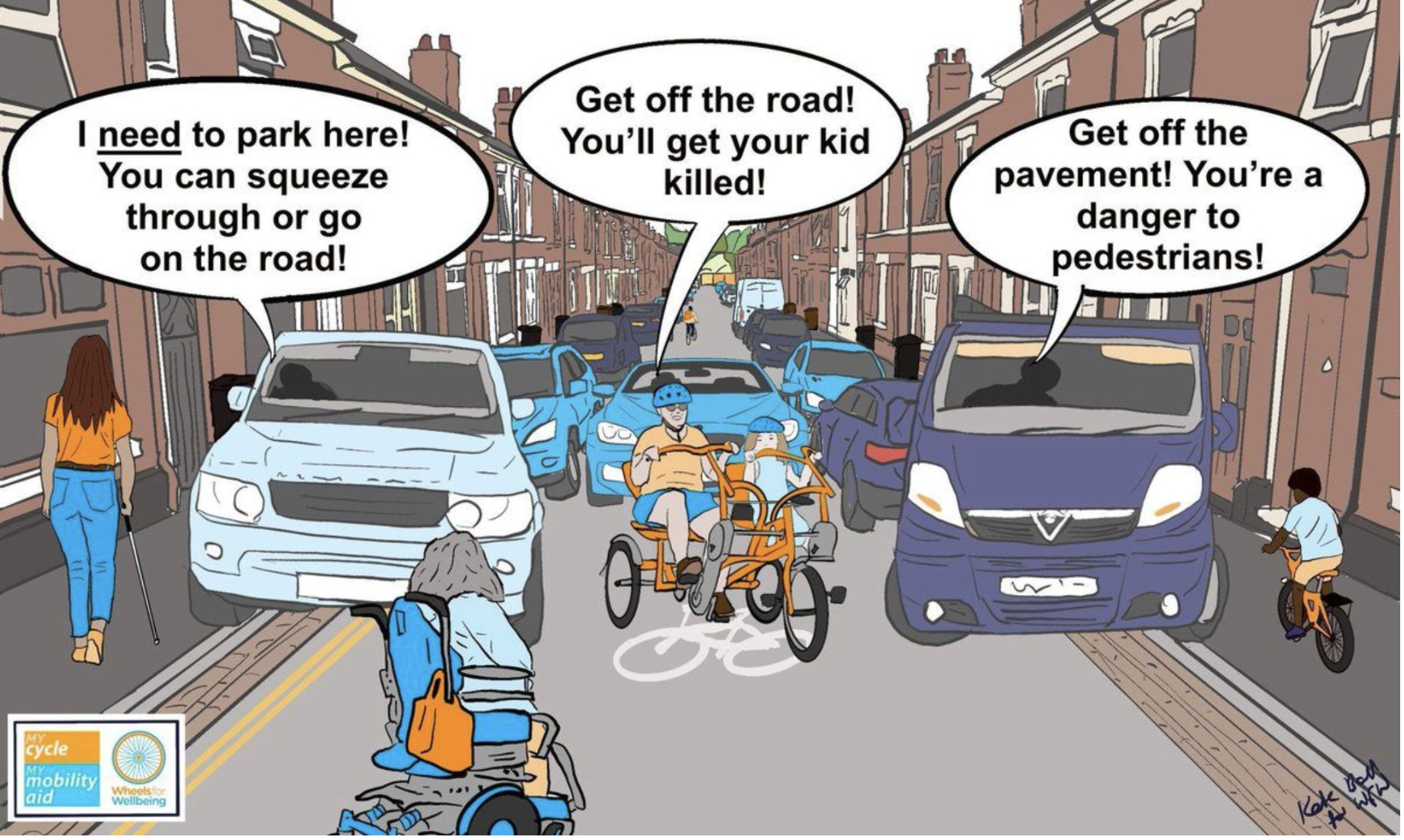
Image cred: Wheels for Wellbeing
But for the people who need pavements, it’s not harmless at all.
What about the wheelchair user who can’t squeeze past? The parent with a pushchair who has to step into the road? The older person who turns back because it feels too risky? Or the blind or partially sighted person suddenly faced with an obstacle they can’t predict?
Wheelchair users / mobility aids: . One person’s evidence to Parliament describes being unable to reach their own parked car because a van blocked the pavement and there was no dropped kerb to get around it.
People with sight loss: Guide Dogs’ evidence to Parliament reports that 95% of respondents with a vision impairment said pavement-parked vehicles had caused them problems. Separate Guide Dogs research reports 1 in 5 people with sight loss reported being injured as a result of vehicles parked on the pavement.
Older people: Living Streets cite research finding that blocked pavements restrict walking for 2.8 million over-65s, increasing risk of inactivity and isolation.
Parents with pushchairs (and young kids): written evidence to Parliament is explicit that prams and pushchairs are among those forced into the road to avoid parked cars, putting them at greater risk of collision and injury.
Added to this; pavements aren’t designed to carry the weight of cars. When drivers mount the kerb, especially in heavier SUVs, they can crack and degrade the surface, creating trip hazards and uneven ground for people walking and wheeling even when there are no vehicles parked.
So pavement parking doesn’t just “inconvenience” people, it can change what journeys are possible and actively cause harm. Of course, here at Oxfordshire Liveable Streets, we welcome this shift. But there’s a catch (and it’s an important one). The Government is choosing a locally-led approach, with flexibility to allow pavement parking where councils deem it acceptable
That means the question for Oxfordshire becomes: what principles are we going to use, consistently, to decide whose access matters most, and where?
This is why a Kerbside Strategy is so vital. Because pavement parking isn’t just a “parking issue”. It’s a decision about:
whether pavements are treated as walking/wheeling space first
whether independence and dignity for people who rely on pavements is non-negotiable
and how we apply fairness when street width is tight, without pushing the burden and risk onto disabled people and families
The OLS watchlist (for what comes next):
Oxfordshire should move quickly to use these powers - and do it in a way that’s clear, consistent and enforceable
Exemptions need a visible equity test: equity of mode, equity across groups, and spatial justice.
And this needs joining up with the wider picture: place-based safety, the LTCP, and kerbside priorities; cycle parking, micromobility bays, car-sharing schemes, loading, greenery, access, so we stop solving one problem by creating another.
3) Cowley LTNs and collision reduction: when fewer cars means more… life ✨
And this is where that ‘golden thread’ we mentioned in the introduction comes alive.
This week, CoHSAT published a third year of collision data from the Cowley Low Traffic Neighbourhoods. The results clearly show a year-on-year reduction in collisions over the duration, with collisions in the LTN area well under half pre-LTN levels,
“There’s a worrying complacency in how we think about road injury and death as the price of getting around, yet every collision ripples through families and communities. CoHSAT’s analysis of three years of data from the Cowley LTNs shows what’s possible when we intentionally design places — from traffic movement to street layouts — around people’s wellbeing: fewer people hurt, less trauma carried by families, and safer everyday journeys for people walking, cycling, wheeling and driving. That’s the outcome we should protect and build on.”
Siobhann Mansel-Pleydell, Oxfordshire Liveable Streets
For traffic schemes, “success metrics” are often expressed in reductions: fewer collisions, fewer injuries, fewer deaths. Necessary, yes, but also bleak. So what’s the flipside? It’s almost impossible to imagine life on the streets with less cars. We’ve been inducted into a culture of ‘motonormativity’ where we literally can't imagine what streets without constant traffic or clogged with parked cars or “not having an accident” would even feel like.
How do you translate “less harm” feel like in the day-to-day?
To get at that, we asked Cowley residents a simple question: what has changed in real life?
“Walking along Cowley Road used to be stressful with drivers turning in and out of every side street. Now Divinity Road is no longer a rat-run - I feel safe letting my older child walk to the Co-op unaccompanied”
“I now feel it’s safe enough to cycle with my daughter down Cowley Road”
“Before the LTNs I felt very anxious walking on narrow pavements with my young kids… it was like walking on the edge of a cliff. The LTNs took away that anxiety and made our route to school peaceful and safe”
“I was too scared to cycle before. Now I cycle to work every day. I love cycling now - and it’s helped me manage stressful times at work”
“The street is calmer and more sociable now… you can talk without our voices being drowned out by the stream of cars..”
And this from our Danny, Infrastucture Co-lead, Director of Oxfordshire Liveable Streets, cycling enthusiast, and Kerb-nerd in residence. Who also happens to be a father. This was back in 2023, published on his blog Wandering Danny
“My daughter (now 10) walks to and from school by herself and likes to dawdle on her way, and I've come to realise that the time to herself, in which she can unwind and relax”
”It is now much easier to stand around and talk, both to neighbours and to people met while walking or cycling”
The Cowley LTN was notoriously rage-filled when it arrived and, at the time, it was genuinely hard for many people to imagine how something so annoying could actually be beneficial. But these are the stories of change we need to hold on to.
A safety strategy here, a pavement parking decision there, an LTN scheme; these interventions shape the direction of travel at two levels: systems change over time, and the texture of everyday life. They shape how we move, how we connect, and whether we can pause and dawdle without feeling on edge. Fundamentally, it’s about dignity, independence, social connection, and the freedom to move safely
So what next?
For us at OLS, it’s another reason to keep pushing for coherent place-based plans, joined-up decision making, and locally meaningful indicators, and perhaps even daring to dream a little about what life could be like when we design streets around people.
On that note, we’ve got a new project for 2026: Future Streets Oxfordshire — a people-powered effort to envision thriving streets and neighbourhoods, and define what “success” looks and feels like. A little bit like we’ve done here but with [spoiler alert] time travel.
Key outputs will include visualisations of what thriving streets/neighbourhoods could look like – for health, community resilience, nature, work, play and connection. To each other and the more-than-human world. AND a first set of locally meaningful, holistic indicators to help us communicate what we want from places beyond “less harm”.
Inclusive participation is vital - as well as active travel enthusiasts, residents, local business and policy makers, we want to bring in seldom-heard voices and those most disproportionately impacted. We will be creating dedicated space for this, but for now we’re sniffing out expressions of interest and local knowledge on who should be ‘in the room’. Here’s a link to a form if you think you might like to be involved, shape inclusive participation, or simply stay in the loop.
Future Streets Oxfordshire : Click here.